

Do you often feel overwhelmed when navigating open water without a GPS? You’re not alone!
This complete guide will show you how to use a GPS effectively to make kayaking easier and even more enjoyable. With the right tools, you can quickly master this essential navigation skill.

In this guide, you will be presented with all of the information necessary to utilize a GPS to help safely navigate your kayak in open water. This guide will cover topics such as understanding how a GPS works, correctly setting up your GPS, using and learning how to interpret data on a basic level, and techniques such as triangulation. Additionally, this guide will bring awareness to the advancements in technology that are increasing accuracy and allowing for safer navigation in open waters without the help of a professional guide.
Once you understand the fundamentals of practical GPS usage while kayaking, you can then use it with full confidence while being aware of important safety tips and navigational guidelines. Knowing how to read maps while backpacking is an important step for those who plan on taking long journeys in open water by kayak or canoe. By combining your knowledge of traditional map reading methods with an understanding of advanced Geographical Positioning System (GPS) devices, you can greatly increase your chances of having a successful kayaking journey.
Choosing the Right GPS for Kayaking
When choosing a GPS for kayaking, it’s important to understand the features and performance of the device. The features of GPS units are often broken down into “trips” and “routes”. Trips are used when you know your destination but don’t have a plan on how to get there. Routes are used when you have a start and end point but need the best route to take in order to travel the required distance.
Other factors that can impact your navigation experience include accuracy, memory capacity, battery life, and display size. A GPS with good accuracy will be able to provide you with an exact location within at least five meters of where you actually are. Memory capacity is also important as it can store more information about data such as waypoints, routes and maps. Maps not only help navigate your route but can also alert you for unforeseen hazards such as hidden rocks or shallow waters.
Ensure battery life is long enough for at least one full day out on the water – something like 15 hours should do nicely! And lastly, chooose a display that’s large enough so you won’t have to squint at it when out on the water – around 4-4.7 inches should be fine!
Considerations for choosing a GPS for kayaking
If you’re planning to embark on a kayaking trip in open water, it’s important to have the right navigational equipment. Having a GPS for kayaking can help you stay safe and avoid areas that could be dangerous. Here are some considerations when choosing a GPS to maximize your time on the water:
- Accuracy: Check what accuracy is offered by your device, especially if you plan to use the GPS for exploring difficult waters or tricky routes. A higher accuracy is better and will offer more detail while navigating.
- Durability: Invest in an outdoor-ready device that has been specifically designed with all-weather conditions in mind. This will protect your GPS from spray, wet weather, dust and dirt on shorelines and other places where you may find yourself using your device.
- Battery life: This is essential; kayaking trips can last several days so ensure you know how long the battery of your chosen device lasts and consider bringing back up charging devices with you on long trips.
- Functionality: Check what functions are available on your device, such as mapping ability and online connection capabilities – this helps plan out routes poorly charted waterways or even connect with other paddlers who are already close by for some navigation help!
- Size & Weight: Your handheld GPS shouldn’t be too bulky otherwise it’ll take up too much room in the kayak, but keep in mind that larger screens may make it easier to read information from further away. Consider investing in protective carrying cases which will also protect against accidental drops overboard!
Recommended features to look for in a GPS for kayaking
When selecting a GPS for kayaking, there are a few key features you should consider before making your purchase. First and foremost, waterproofing is essential. Additionally, it’s important to make sure your device has an ample battery life when outside of cell service since some additional features may require more power. Another feature you should look for is detailed mapping and navigation capabilities so that you can precisely locate yourself while paddling on open water.
Another useful feature is the ability to “mark” specific locations or routes that you have previously taken in order to easily find them again in the future. Additionally, most GPS devices readily offer information regarding local tide schedules as well as fishing and weather forecasts so that you can be aware of potential conditions on the water. Finally, having an emergency beacon or other safety mechanism built into your device can ensure a quick response from rescue teams if ever needed in case of trouble at sea.
III. Understanding GPS Navigation
The use of a GPS is a great way to navigate your kayak in open water. With a setup that will allow you to track your position and plan out your route, it is possible to make navigating open waters easier and more convenient. In this guide, we will discuss the basics of understanding GPS navigation, the different types of units available on the market, and how to get the most out of them.
One of the primary advantages to using a GPS system when kayaking is that it allows you to more accurately identify and navigate towards points of interest along a particular route. With traditional navigation methods such as map reading or plotting with a compass, it can be difficult to pinpoint specific spots along your route for short-term breaks or outdoor exploration purposes. However, with the use of electronic navigation methods such as GPS plotting or map display features on certain models, users can much more accurately determine exactly where they are located or wanting to go.
GPS mapping devices come in different shapes and sizes from handheld units that are small enough for transport in most kayaks, full-sized waterproof computers preinstalled with NOAA nautical charts, or even satellite based messaging programs for long-distance boat travelers and ocean vessels. Understanding all these types including their various function sets is an important process when trying to determine which one will best suit your needs while kayaking.
Basics of GPS navigation
GPS navigation (Global Positioning System) is a technology that relies on satellite systems to track a device’s location. Using accurate information about your location, a GPS can help you navigate when out on the water. Knowing how to use and understand a GPS is essential for anyone venturing onto open water in their kayak.
There are several basics of GPS navigation you should understand before you try using it to navigate by your kayak:
– Many modern cell phones have built-in GPS capabilities, but these often rely on cell towers and can have trouble connecting in more remote areas. Therefore, it is important to always carry a dedicated handheld GPS device if your trip takes you away from the coast or into more remote areas.
– Your GPS will be able to record and save coordinates that allow you to retrace routes and measure distances accurately. This is especially useful when exploring bodies of water that may not have detailed navigational maps available online.
– You should also become familiar with how to enter coordinates into your device as well as how to use its zoom feature, which can help reduce errors due to inaccurate readings or shadows along shorelines. By understanding these basics, you can confidently go out on open water with the knowledge that your whereabouts are secure thanks to your trusty GPS unit.
How to read GPS coordinates and maps
Reading and interpreting GPS coordinates and maps is the second part of navigating with a GPS. Knowing where you are on the map or in the water is fundamental to successful navigation. GPS coordinates are usually given in latitude and longitude, but can also be given in UTM (Universal Transverse Mercator) or USNG (United States National Grid).
A good way to understand this is to think of your boat as sitting at a point in space above the surface of the earth. To find yourself on a map, you need to know both latitude and longitude. Latitude gives your boat’s position north-south along a line of constant temperature (the Equator) while longitude gives its position east-west along a line going right through the Earth’s poles.
Your boat will always sit at two points on the Earth represented by its own unique set of coordinates using minutes, seconds and decimals of degrees. For example, 42°38’20” N x 71°08’20” W would be read as 42 degrees 38 minutes 20 seconds North and 71 degrees 8 minutes 20 seconds West – these coordinates would pinpoint your exact location close enough for most outdoor recreational activities like kayaking.
Reading topographic maps can enable you to see terrain features relevant for navigation such as contour lines, landmarks, man-made roads or paths which can provide an extra level of detail not visible from your starting point or destination point(s). It’s best to study topographic maps before embarking so that you have an idea what kind of terrain should provide clues when it comes time to navigate your kayak journey.
Understanding GPS waypoints and tracks
Knowing how to use GPS waypoints and tracks can be invaluable for kayaking in open water. GPS waypoints are a set of data points which specify the location, date and time saved by a GPS receiver to identify specific locations. Tracks are like breadcrumbs, showing the exact route followed and can be used to retrace your steps or create a route that you want to follow. In either case, it’s valuable information that will help you stay on track and make sure you don’t get lost while kayaking in open water.
When navigating while kayaking, it is important to also understand the terminology associated with waypoints. A “COG” or “course over ground” refers to your current heading as determined by your GPS receiver; an ETB or estimated time of arrival indicates when you should arrive at a given location based upon your current speed; an ETA or estimated time en route is similar but is based upon the previously traveled course. The last of these terms are particularly important when using tracks, as they allow you project how long it should take for you to reach any given point on your course.
GPS waypoints can also be combined with range circles in order create detailed navigation plans from a single point of reference (such as your starting position) which will ensure that you stay within range of watchful eyes on shore if necessary and will provide valuable cross-checks along the way to help prevent getting lost while kayaking in open water. By understanding these terms and knowing how they work together you can confidently explore waters near and far without worry!
Preparing Your GPS for Kayaking
Having a GPS device on hand to safely navigate open waters is an invaluable tool for kayakers. Before you start your kayaking adventure, you should ensure that your GPS is prepped correctly to ensure optimal performance. Here are some key steps you can take to get the most out of your GPS during your journey:
- Set up an appropriate area for access points: If you don’t have a Satellite network connection, you’ll need to create one in order to receive location updates on the shoreline. With AccuPoint technology, you can mark routes such as land boundaries and points of interest that provide reliable navigation data anywhere in the world.
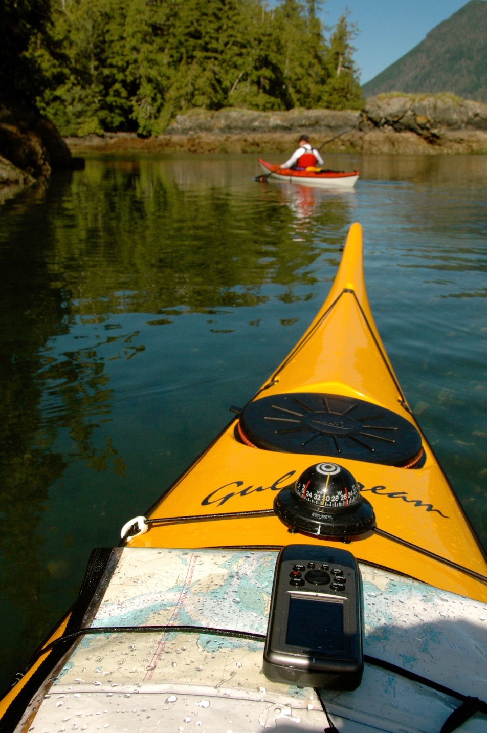
- Acquire the necessary Marine charts: Gulf Stream charts provide navigational data critical for outside navigation safety and identify potential danger zones such as shallow waters or hidden pitfalls. Electronic nautical charts allow individuals to download relevant data directly into their GPS device, allowing them to trace detailed routable paths through water ways both near and far away from shorelines.
- Update maps and software before each trip: Outdated maps may contain inaccurate information that could lead to costly mis-navigation events, so be sure to ensure all software systems are updated before your next voyage into open water by downloading the latest regional charts from online sources or marine services providers . In addition, consider setting up a custom watch list with spots that can be updated along your journey so that if trouble occurs at any point along the way it can be flagged immediately — helping increase response times from shore or other vessels if necessary.
- Configure tracking settings for improved accuracy: Kayakers will want optical sensors installed in their device’s software in order for itto track position accurately when outdoors — helping reduce confusion when attempting complex maneuvers such as navigating narrow channels or tight builds with deep aquatic environments where factors like currents and winds influence movement significantly more than usual land journeys would experience . By setting up tracking parameters correctly users can easily monitor their current location throughoutany journey they embark upon – increasing safety levels substantially in potentially hazardous environments like open ocean waters.
Setting up your GPS before heading out
Before you head out, it’s important to make sure that your GPS unit is properly set up so that it can accurately track and guide your kayak in open water. Here’s a step-by-step guide:
- Get your charts and maps. Most GPS units come preloaded with detailed charting information, but it’s always good to have your own up-to-date charts in case you venture into unfamiliar territory. Your local nautical store or online retailer should have the most recent versions of these materials.
- Acquire the necessary software and accessories. Depending on the type of GPS unit you have, different software upgrades may be needed to ensure accurate navigation in different areas and under certain conditions. Make sure you purchase any necessary updates or accessories before departing on your voyage (e.g., a differential antenna for satellites).
- Familiarize yourself with how to use the GPS unit properly (e.g., how to enter coordinates, create waypoints, follow routes). Many models come with user manuals and quick start guides that can help you get used to the device quickly; however, it is important to understand exactly how each features works before attempting to use them at sea or on a large body of water.
Calibrating your GPS for accuracy
Calibrating your GPS is an important step towards ensuring your GPS will be delivering accurate readings to help you navigate in new, unfamiliar areas. On most modern handheld and wearable GPS devices, calibrating is a simple process. Generally, all you need to do is follow the prompts on the device’s interface. But if you’re using an older model or otherwise uncertain about how to calibrate properly, consult the manual that came with the device or look online for official directions from the manufacturer.
When it comes to kayaking out in open water, many people mistakenly assume that their GPS readings are correct every time they glance down at them – but this isn’t always true! In fact, even if you calibrate properly with your device whenever necessary, there are still several factors that can affect overall accuracy and precision when operating in open water. Potential sources of error include magnetic interference, such as nearby power lines or electromagnetic fields emitted by large boats; extreme weather conditions like wind or fog; and even sunspots or atmospheric pressure changes.
To take full advantage of your GPS while kayaking in open water, be sure to periodically verify its accuracy by taking a few moments to stop paddling and ensure your current position matches what you entered into your GPS before setting off on your journey!
Saving waypoints and creating a route
Creating a route on your GPS is as simple as saving waypoints along the path you intend to take. Waypoints are simply spots you save to help you navigate back to a particular area in the future. A great thing about modern GPS units is that creating a route from these waypoints is often automated, so you won’t be doing any complex calculations yourself.
To create a route on your GPS unit, start by creating a waypoint for each spot where you want to turn your kayak. Then, save the route by providing it with an appropriate name and set the sequential route points in order along your path. Once all the points are added, the GPS will automatically cause your kayak to turn when it passes near each point in the prescribed order — allowing you to concentrate more on executing the perfect paddle stroke and less on navigating!
Conclusion
When you are out on the open water in your kayak, having a good understanding of where you are and how to get back to shore can make all the difference. A GPS device is a great tool for helping you do this, providing both an accurate location and direction along with useful navigational features such as waypoints, route planing and more.
However, it’s important to remember that GPS technology is not fool-proof; factors such as satellite availability, weather conditions, physical obstructions and other factors can interfere with its function. Taking the time to understand the capabilities of your GPS device and how to use it properly will help ensure your safety when kayaking on open water.
So break out your laptop or smartphone, consult your manual and get familiar with how a GPS works – chances are high that by doing so you’ll improve your kayaking experience!
FAQ’s
Do you need a GPS for kayaking?
It’s not necessary, but it can be helpful, especially for longer trips or in unfamiliar areas.
How do you navigate a kayak?
You can navigate a kayak by using a compass, landmarks, and/or GPS. It’s important to have a general sense of direction and know how to read a map.
How do you track distance when kayaking?
You can use a GPS device, a smartphone app, or a manual paddle wheel to track distance when kayaking.
What is the best GPS for kayak?
There are many good options, including the Garmin GPSMAP 64st, the DeLorme inReach Explorer+, and the Magellan eXplorist 510.
What is the best handheld GPS for sea kayaking?
The Garmin GPSMAP 66i is a popular choice for sea kayaking, as it has satellite communication capabilities and can also be used as a two-way messaging device.
What personal safety device do you need for kayaking?
A personal flotation device (PFD) is essential for kayaking, as it can help keep you afloat if you fall into the water.
What technology does kayak use?
Kayaks themselves don’t use technology, but kayakers may use GPS devices, fishfinders, or other electronic gadgets while on the water.
What piece of equipment is used to move a kayak through the water?
A paddle is used to move a kayak through the water.
How do you carry your phone while kayaking?
You can use a waterproof phone case or a dry bag to carry your phone while kayaking, or you can leave it in a secure location on land.
What you do in a kayak to move through the water?
To move through the water in a kayak, you use a paddle to propel the boat forward. You can also use your body weight to steer the kayak and maintain balance.
See Also-
- Best golf gps 2023
- Best cat gps tracker 2023
- Best fish finder gps combo 2023
- Best trucker gps 2023
- Best gps for kayak 2023