
Have you ever wondered how drones can help survey the landscape efficiently and effectively?
GPS drones are the perfect solution, providing organizations with high-precision mapping and surveying in a fraction of the time. Learn all about the role of GPS drones in surveying and mapping – from data accuracy to cost-effectiveness – with this complete guide.

Surveying and mapping are key components of many engineering and construction projects and technological advances have revolutionized the way these tasks are accomplished. Drones armed with global positioning system (GPS) technology are quickly becoming one of the most effective ways to measure, map, and analyze various types of terrain.
This guide will provide an overview of how drones can be used for surveying and mapping applications and how GPS systems can aid in precision measurement, accuracy, data analysis, cost savings, data transfer, imagery/photo capture, automatic alert generation, safety, mobility with land-based surveying equipment limitations.
The first section will look at the basics of surveying and mapping before discussing some potential applications in detail. Next we’ll examine the different types of drones available for this purpose and what specific advantages each type offers for various types of terrain. We’ll then discuss GPS technology and its role in drone navigation as well as ground positioning systems like RTK (real-time kinematic).
The guide will next describe the benefits that come from utilizing high-precision photogrammetry to produce detailed 3D models. We’ll follow by looking at methods for analyzing aerial data before finishing with a discussion on the safety protocols employed when using remotely operated aircraft to survey hard-to-reach areas or hazardous environments.
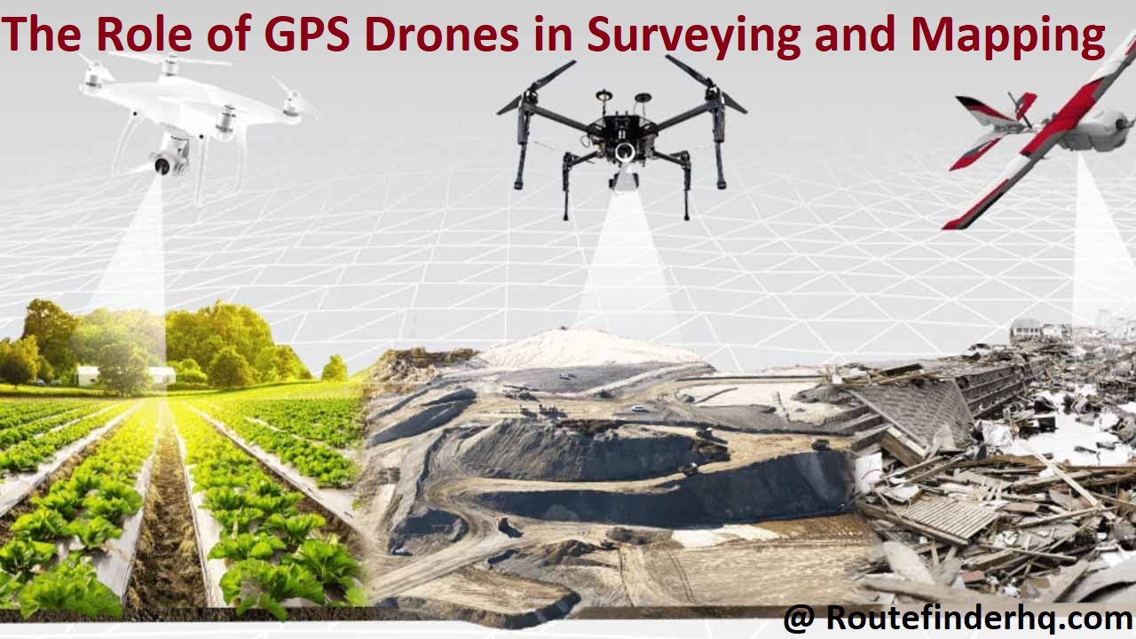
GPS Drones in Surveying and Mapping
GPS drones are revolutionizing surveying and mapping technology. By utilizing the latest GPS and navigation systems, drones can scan, measure and map a wide range of outdoor spaces with unparalleled accuracy and efficiency. This technology is increasingly being used to survey everything from land to agricultural fields, buildings, forests and other natural features.
The use of GPS drones enables surveyors and mappers to collect vast amounts of data in a relatively short amount of time. Accurate information is obtained quickly in comparison to traditional ground-based measurement methods. Drones also allow for high-precision measurements that are less affected by line-of-sight obstructions or other issues that can affect ground-based measurements.
Capturing high resolution aerial images with a drone allows for detailed digital terrain models (DTM) to be produced from which accurate topographical maps can be generated from contour lines by surveyors in the office post flight mission data processing or out in the field during onsite operations. Multi view point captures elevate the data accuracy levels such as absolute height accuracy or ground curvature profiles relying on stereo image pair measurements. Utilization of geospatial software allows users to measure area/distance, store intersecting points/markers/trajectories, calculate elevations relative to sea level or profile measurements along tracks for highways design or river assessment tasks such as culvert locations for water flow analysis applications.
Additionally using effective mapping algorithms with flight mission planning software allows users to optimally plan survey routes so as to maximize coverage and minimize overlap reducing both flying time (battery usage) while at all times ensuring safety during flight operations, hence minimizing risk associated with proximity of obstacles & aircraft collision potential risks present when conducting manned aerial survey flights by traditional aircrafts.
What are GPS drones
GPS drones are unmanned aerial vehicles (UAV) that use Global Positioning System (GPS) technology for navigation, flight planning, and data collection. These multirotor aircrafts are typically equipped with a range of sensors that allow them to capture data from the ground or from airborne platforms, including: low-altitude geospatial imagery and LiDAR. These services that collect information from above are commonly referred to as photogrammetry and lidar mapping/surveying services.
Drones equipped with GPS technology provide an efficient, cost-effective way for users to survey large tracts of land for a variety of purposes. In addition to providing real-time data on the ground, GPS drones can also perform other tasks such as creating 3D models of structures or providing virtual reality tours of difficult-to-reach locations.
With its unique combination of flight planning capabilities and versatile sensors, this technology offers significant potential in the realm of surveying and mapping applications.
How do GPS drones work
GPS drones use Global Positioning System (GPS) technology to fly autonomously over a given area. They are equipped with precise navigation systems that enable them to collect data from any given point and transmit it back in real time. These drones are mainly used for surveying, mapping and measuring purposes.
For surveying and mapping, GPS drones rely on a variety of sensors and technologies to capture accurate 3D information about the terrain or object being surveyed. They use multi-spectral sensors, such as cameras or infrared sensors, to take multispectral images of the area being surveyed. This captured data then goes through a series of algorithms that are designed to stitch together the various images into an integrated 3D map. By combining the gathered data with GPS coordinates, these maps can be incredibly detailed and highly precise – providing valuable information for both commercial uses and scientific research projects alike.
With GPS drone technology improving daily, even more applications are being developed and explored in various industries today including agriculture, landscape management, engineering/construction planning and much more. The data collected by these advanced systems is incredibly valuable in helping businesses make informed decisions while minimizing risks associated with physical labor or other hazardous activities onsite.
Benefits of using GPS drones in surveying and mapping
There are several advantages of using GPS drones for surveying and mapping. First and foremost, it allows the surveyor to collect data in areas otherwise difficult or impossible to access, such as remote locations, coastal areas, difficult terrain, over water or in hazardous conditions. Let’s take a look at other benefits of using GPS drones in surveying projects:
– Increased Accuracy: Drones are capable of producing high resolution imagery with accurate geo-referencing capabilities that make it easier for surveyors to measure distances more accurately than ever before. The drone also allows complete coverage of the land with no areas left out from the survey which increases accuracy as compared to traditional methods.
– Cost Efficiency: Using a drone eliminates the need for additional personnel that is usually required in traditional survey methods such as ground truthing and restaking activities. By reducing personnel requirements organizations are able to save on cost incurred by hiring staff for specialized roles.

– Increased Data Collection Speed: The speed of data collection combined with reduced personnel requirement enables organisations to quickly generate reports which would take days if not weeks using traditional methods making it a great way to save time while accurately capturing information.
– Time Savings: Surveys conducted completely by aerial imagery eliminate hazardous work conditions on high cliffs or slopes where human lives can be put at risk during surveys conducted by handheld GPS devices or total stations or even when identifying obstacles on the terrain after ground truthing has been completed on location that would have required extra labour costs were these surveys conducted manually without the aid of a drone. In some cases multiple truthing missions may have to be conducted across different times due to external factors such as bad weather disrupting operations further increasing time consumed by projects and associated costs.
III. Applications of GPS Drones in Surveying and Mapping
The rise of GPS drones has revolutionized the surveying and mapping industries. By leveraging the accuracy, reach and precision of drones coupled with highly accurate GPS receivers, surveyors can access previously difficult-to-reach areas and make more accurate measurements in a fraction of the time. Here are some of the common applications of GPS drones in surveying and mapping:
Aerial Surveys: The most common application of GPS drones is performing aerial surveys. Through flying a drone equipped with a high-resolution camera and accurate GPS receivers, surveyors can capture detailed aerial images for use in creating 2D maps or 3D models to produce data that can be used for planning, modeling, monitoring projects etc.
Topographic Mapping: Drones also allow for topographic mapping which is a detailed process that involves gathering elevation data over an area for use in land management or engineering projects. This type of mapping requires multiple flights with highly accurate imaging capability as well as precision GPs tracking systems to ensure accuracy throughout the entire process.
Flood Mapping: With high resolution imaging sensors on board their drone platform, surveyors can create incredibly detailed maps of areas affected by floods, giving engineers invaluable information on which they can design plans to manage and prevent further flood damage. Additionally by capturing depth data in bodies and streams, they can plan interventions accordingly when preparing response plans that involve land drainage features as part of post flood management operations.
Construction Site Surveys: Construction sites require frequent surveying to check progress but are often too dangerous or too far away from infrastructure to conduct manually. Drone technology has enabled surveyors to capture construction site data remotely without having to put personnel safety at risk. High resolution cameras coupled with advanced sensors mounted on drone platforms provide almost real – time information about such projects enabling better monitoring as well as quicker decision making amongst stakeholders involved in construction projects.
Land surveying
The use of GPS drones in land surveying is one of the most common applications. GPS-enabled drones can be used to produce highly accurate 3D maps of large areas that would traditionally have required multiple surveyors. This significantly reduces the amount of time and cost associated with land surveying, as well as reduces the risk of human error. The usage of GPS-enabled drones allows for a more detailed view than traditional surveying techniques, and can produce more exact geographic data that take into account not only positioning, but also elevation measurements as well. This data is then used by professionals in a wide range of activities, such as engineering projects and urban planning initiatives.
Additionally, the use of drone technology may allow for greater efficiency in acquiring difficult to access areas that previously would have required complex or risky maneuvers for a human surveyor.
Construction site surveying
The use of GPS drones has become extremely popular in the construction industry for surveying complex terrain before and during the construction process. Drones can provide extremely accurate information, potentially cutting costs by as much as 75 percent compared to traditional survey methods. In addition to getting accurate measurements, it is possible to gain a larger context of the project, with higher resolution and better detail photographs providing more insight into planning and problem solving onsite.
The use of drones provides unique advantages in site surveying that would be virtually impossible with traditional methods. Construction site surveyors can take advantage of this technology to give accurate readings on physical dimensions within a plot or area they are surveying. Surveyors can also classify objects such as trees, fences, roads etc. and integrate the 3D data into their existing workflows incorporating tools such as AutoCAD or 3DS Max. In addition, surveyors can produce digital elevation models (DEMs) from aerial images quickly and effectively without having to conduct field surveys manually.
By using GPS-enabled drones with software solutions such as Pix4Dmapper Pro for inspection & reality capture onsite, surveyors are able to inspect hard-to-reach places safely without having to climb structures or leave their vehicle for long distances in hazardous terrain – saving time and money.
Agricultural mapping
GPS drones can be utilized to create accurate topographical maps. This is especially useful for agricultural mapping as it helps farmers and growers to understand terrain features such as altitude and slope, which can play an important role in the success of the crop. By measuring elevation and calculating changes, drones can help farmers make informed decisions when it comes to cultivating their land.
Additionally, GPS drones can be used to generate detailed aerial maps of the land, allowing growers to get a snapshot of vegetation health and transects which typically provide valuable insights into crop growth and potential soil erosion problems. This ensures that crops are planted in the right areas with optimal soil fertility while also identifying potential flood risks. This data also allows farmers to easily plan fields sizes and boundaries while supporting precision agriculture initiatives with real-time field observation. Using this type of mapping technology, growers can get better yields from their crops with less risk of poor performance due to poor land conditions.
Factors to Consider when Choosing a GPS Drone for Surveying and Mapping
When selecting a GPS drone for surveying and mapping, several important factors should be considered. While the basic factors, such as cost and speed, are fairly straightforward, other considerations are also important. This section will provide an overview of the main factors that have an impact on the suitability of a particular drone for surveying and mapping applications.
- Camera Quality: The camera quality is essential for producing accurate results from any aerial survey or mapping project. Look for drones that feature high-resolution sensors to ensure accurate data collection. Additionally, look for options with adjustable settings, allowing users to adjust their camera settings depending on the area they are surveying or focusing on. Finally, consider drones with interchangeable lenses to get different perspectives without having to purchase additional cameras or sensors.
- Stability: When it comes to accuracy, the stability of a drone can be just as important as its camera quality. Look for models with vibration-reducing technologies, such as gimbals or camera-stabilizing technology which ensure high precision despite turbulence and windy conditions during flight times. Additionally, payload capacity can impact stability in flights; make sure you check this figure when choosing your equipment to ensure maximal stability during all your projects phases including launch and landings.
- Range: Surveillance and mapping over large areas require drones with long ranges. Communication between GPS-enabled drones and the ground station should be reliable up to kilometers since otherwise there may be interruption in data collection even if the flight time has been accounted for. Many tracking systems rely on periodic interaction between the two, so make sure you find models that include enhanced connectivity features such as extended ranges and beyond line-of-sight capabilities.
- Battery Life: For extended drone use, smaller batteries would mean more frequent charging rotations or purchasing multiple batteries, which could easily increase expenses related to owning a GPS drone significantly. When choosing your equipment, look at its battery life and consider how much time it takes to recharge so that these elements fit into your expedition’s needs while providing maximum endurance within one charging rotation (typically 30 minutes).
- Data Storage: Aerial surveys produce huge amounts of data, so check if your selected model has enough onboard storage space before purchase if applicable. Furthermore, look out for models with extra slots for USB flash drives in case there is need for increased memory space where local storage may not suffice. Find out what kind of media each holder situations how many provided with their data loss do onbeth models offer (SD cards, CDRs etc).
Accuracy and precision
Accuracy and precision are essential factors in surveying and mapping, and GPS Drones can be highly precise in measuring angles, distances, and areas. Using precise angle measurements with ultra-wide lens cameras and using trilateration to measure distances over longer distances with carrier phase corrections to improve accuracy achieves results which have just been impossible for the past years.
In particular, the centimeter-level accuracy achievable offers exceptional value for certain types of applications that require high-accuracy mapping. These include photogrammetry (coupled with imagery from drone cameras) as well as autonomous surveys (for land management purposes).
By combining sophisticated parameters such as Relative orbit positioning/tracking Accuracy/Orbital Reproducibility, Resolution of Coded Modulated Targets (CMTRs), Number of Targets Viewed per Scan Line(TCVL), Ranging Segments per Scan Line (RSVL), Security Level of Message Structure Formatting package(SLF/MSCF) ,the achievable accuracy can exceed 0.02 meters although this will depend largely on the initial conditions, flight environment and hardware used in the operational service. This high level of accuracy has made drones more usable compared to traditional manned aerial survey systems like the Surveyor’s plane which achieve accuracies usually between 5cm -60 cm depending on camera type & system setup conditions.
Battery life and flight time
It is important to consider the battery life and flight time when using GPS drones for surveying and mapping. Most commercially available UAVs have limited battery life, usually lasting between 15 minutes and one hour. This limits the area that can be mapped in each flight, thus increasing the need for multiple flights. To maximize the area that can be mapped, it is important to select a drone with longer battery life and increased flight times.
Battery life can also depend upon variables such as temperature, altitude, payload weight, terrain features and wind speed or direction. High temperatures are known to reduce battery life significantly due to increased air resistance placed on aircrafts as they ascend or descent from lower to higher altitudes. As such, it is important for operators to recognize this in order understand when drone batteries may require additional recharging before being deployed for aerial surveys or mapping missions. Furthermore, if an operator expects exceptionally long-term surveying missions or flights that take several hours then selecting UAVs with swappable batteries may be necessary in order to reduce downtime while keeping operations running continuously.
Payload capacity
The payload capacity of a GPS drone is an important factor to consider when using it for surveying and mapping purposes. Payload is the total weight of materials, equipment, payload mass and additional payload which the drone can carry while in flight. Depending on your needs, you can choose a drone with any desired payload capacity.
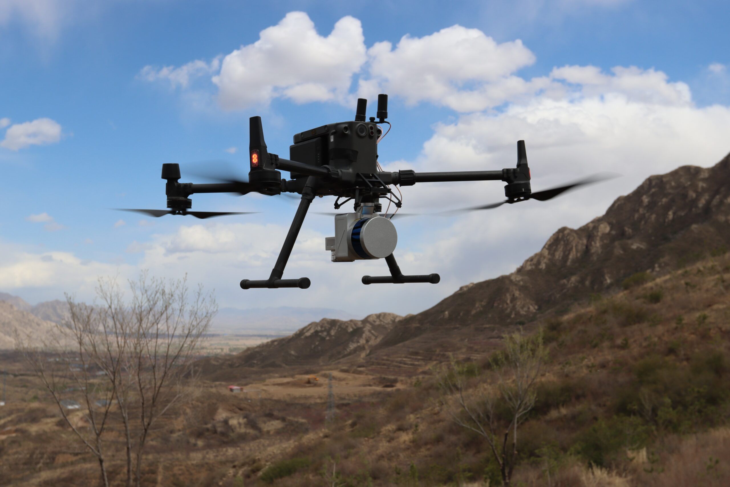
The most common use cases for drones with larger payloads are industrial applications such as inspection or data collection projects that require multiple sensors or cameras to be used at once. Additionally, some drones are specifically designed to carry large objects such as medical equipment or supplies. This type of mission may require a higher payload capacity than other types of missions like traditional aerial photography or videography purposes.
When selecting a drone based on its payload capabilities, consider the overall size and weight of your sensor/camera/equipment that you need to mount to the UAV along with any additional components like extra batteries. As GPS drones vary widely in terms of their capabilities, it’s always best to double-check that your chosen model is capable of carrying all your desired components without compromising its flight performance.
Conclusion
In conclusion, GPS drones are revolutionizing the way surveying and mapping is being done. By providing an affordable, efficient and convenient way to access difficult and dangerous terrain, they are becoming invaluable tools for engineers, surveyors and other professionals who need high-resolution information in a short amount of time. With the technology advancing day by day, they may soon become a must-have tool for anyone wanting to get involved in aerial mapping or surveying.
GPS drones provide numerous advantages over traditional ground-based surveying techniques. They reduce labor costs since initial data gathering can be done much faster compared to manual methods. The use of specialized imaging software can also help improve accuracy and reliability of results without having to worry about environmental factors such as wind or terrain irregularities affecting the data collected. Additionally, GPS drones provide access to airspace that was previously unreachable or expensive to access with manned aircrafts or satellite imagery.
The versatility of these tools makes them an ideal choice for anyone needing to obtain aerial imagery or perform topographic surveys quickly, accurately and cost-effectively. As these systems continue to become more affordable while offering higher resolution images and greater flexibility over traditional methods, there’s no doubt that they will continue their ascendancy as the go-to solution for mapping professionals across the globe.
FAQ’s
What is the use of drones in surveying and mapping?
Drones are used in surveying and mapping to gather high-resolution data, create accurate maps, and produce 3D models of landscapes, buildings, and infrastructure.
What is the importance of drone in surveying?
Drones have revolutionized surveying by providing faster, more accurate, and cost-effective data collection, especially in remote or inaccessible areas.
How does GPS work in surveying?
GPS (Global Positioning System) uses a network of satellites to determine the precise location of a receiver on the earth’s surface, which is used in surveying to establish coordinates for mapping and construction.
What are three 3 benefits of using the drone?
Three benefits of using drones are cost-effectiveness, faster data collection, and improved safety for surveyors and construction workers.
What are the main purposes of drones?
The main purposes of drones include aerial photography and videography, surveying and mapping, inspection and monitoring, search and rescue, and delivery of goods.
What is the biggest advantage of drones?
The biggest advantage of drones is their ability to access hard-to-reach or dangerous areas, reducing the need for humans to perform risky tasks.
What are the main uses of drones?
The main uses of drones include photography and videography, surveying and mapping, inspection and monitoring, search and rescue, and military and defense applications.
What are 6 uses of drones?
Six uses of drones include agriculture, conservation, journalism, emergency response, infrastructure inspection, and entertainment.
What are some uses for drones give 5 examples?
Some uses for drones include land surveying, real estate photography, construction site monitoring, disaster assessment, and wildlife monitoring.
What are the application of drone in engineering?
Drones have various applications in engineering, such as mapping and surveying construction sites, monitoring and inspecting infrastructure, and conducting aerial surveys for planning and development purposes.
See Also-
- Best golf gps 2023
- Best cat gps tracker 2023
- Best fish finder gps combo 2023
- Best trucker gps 2023
- Best gps for kayak 2023