
Feeling lost at sea? With modern GPS technology, you no longer have to worry about navigating on the open waters.
This complete guide outlines the essential role of GPS in boat navigation and safety, helping you keep your vessel safe and enjoy a smooth sailing experience.
The Global Positioning System (GPS) is a network of satellites that transmit precise coordinate data to receivers here on Earth. This technology has made it possible for mariners to know exactly where they are and how to get from one place to another.

This guide will explore the different types of GPS units available for boating and how to maximize their use for navigation and safety. It will focus on how GPS helps boaters make informed decisions about their travels, as well as provide useful tips on using your system properly.
We’ll also look at some of the most common technical problems associated with GPS systems, so you can understand what can go wrong and troubleshoot any issues with ease. Finally, we’ll discuss some of the most popular navigation apps used by boaters today and explain why more mariners are making the switch from paper maps to digital ones.
The Importance of Navigation and Safety in Boating
Good boat navigation and safety can literally mean the difference between life and death. Even if you’re only heading out on a short weekend fishing trip, there are numerous risks and dangers associated with being on the open water. In knowing how to properly navigate, you can avoid certain hazards, such as shallow waters, dangerous rocks, and even inclement weather. This is why all mariners should understand the importance of having a reliable navigation system – specifically Global Positioning System (GPS).
GPS is an advanced global navigation satellite system that enables users to accurately determine their position anywhere in the world by collecting data from multiple satellites orbiting Earth. Using this technology is essential for anyone who wants to safely navigate on open water, as it provides an easy-to-follow course map on their vessel’s onboard display. Not only will users be able to view their current location while at sea, but they’ll also be able to plot a course towards their destination – ensuring that they take the most efficient route possible. Additionally, GPS can provide vital navigational information such as water depth readings and ocean currents – ensuring that boaters stay away from any potentially hazardous areas of water.
The risks involved in boating without navigation tools
Before the age of GPS navigation, boaters relied on charts and maps, compass, and sextant to safely find their way. While these tools are still valid boating navigation options, they do not provide the real-time accuracy that GPS navigation systems provide. Incorrectly used or interpreted navigation tools can lead to numerous issues such as calculating inaccurate courses of travel, sailing into areas where restricted activities are conducted, running aground on rocks or sand bars in shallow water which can damage or overturn a boat or getting lost.
In addition to traditional navigation tools, boaters without real-time datalogging and mapping capabilities can get into trouble quickly when out of sight of land. They may be unable to accurately determine their position in relation to shoals or other hazards that could potentially cause them danger. This is especially true in areas with choppy waters due to storms, rough conditions caused by strong currents and tides, or simply being unfamiliar with the area they are navigating through. Without access to updated weather forecasts they might find themselves in dangerous situations before they even realize it — their safety compromised because of a lack of knowledge about their location and conditions around them.
Utilizing GPS technology within a thoroughly planned navigational plan provides mariners with up-to-date data helpful for finding safe routes more quickly and easily than ever before. Having an onboard sophisticated navigational plotting system enhances both accuracy and safety for recreational boaters and seafarers alike — helping them make better routing decisions by offering a detailed view of the surrounding ocean environment including critical obstructions below the surface (such as pinnacles) as well as potential anchoring grounds. In case of unexpected events such as fog obscuring visibility in harbor entrances, GPS systems allow for improved precision even when weather conditions amounting to visibility reduction occur.
The benefits of using navigation tools
GPS receivers that are accurately linked to a boat’s navigation system provide boaters with added confidence and convenience, particularly in unfamiliar waters. GPS allows boaters to plan their trips and view the surrounding waterways on a digital chart or map. It’s an essential tool for knowing where they are and avoiding collisions, suitable for recreational boating and commercial shipping.
Using GPS makes navigation more reliable by giving an exact location and the time readouts are accurate to within approximately 10-15 milliseconds of GMT (Greenwich Mean Time). This accuracy enables navigators to plan their routes precisely, and select suitable transits or channels given the relevant conditions like tides or weather.
Unique digital technology also means captains can mark points of interest along the way so they never forget a place when returning to it again. Having this capability ensures that trips can be optimized from start to finish with maximum safety and efficiency. Night-time navigation through unlit areas is also made much easier as GPS is capable of providing visual representations of shoreline features, which may not be visible at night otherwise.
In addition, modern navigation systems have depth-sounder and radar capability built right into their interface making them an ideal tool for exploring unfamiliar waterways or fishing waters with minimal risk of running aground in shallow water. They also come integrated with watchman capabilities, allowing captains to keep track of all vessels in their vicinity by setting custom boundaries around zones where other vessels should not enter – such as when entering port or navigating through congestion areas offshore.
III. GPS and Boat Navigation
GPS has become an essential tool for boat navigation. With a GPS receiver and accurate maps, sailors are now able to easily pinpoint their exact location on the open water, and accurately calculate the time it will take to reach a destination.
GPS systems also provide boat navigators with critical information about the depth of water beneath them and markers from past expeditions to help identify known hazards or shallow areas. With GPS audio alerts, users can be quickly alerted of any changes in ownship direction, speed or proximity to danger zones or other vessels in the area. This critical information is used by navigators to make quick decisions on changing course or adjusting speed in order to avoid dangerous situations.
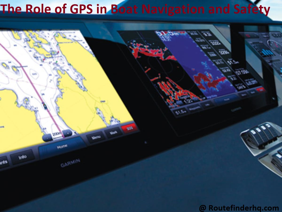
GPS receivers come equipped with multiple map layers which show essential navigation data such as Cartesian points, buoys and lighthouses along with other sailing related information like weather forecasts and coastal surveys which helps sailors have a more informed sailing experience. As an example, the Garmin GPSMAP 1222 boats typically comes standard with highly detailed 1-foot bathymetric maps so that fishing boat anglers know where they are most likely to find fish in order to maximize their time on the water.
In addition, GPS also fully integrates AIS (Automatic Identification System), a system designed for monitoring ship movements which broadcasts vital navigational data like position, course and speed data between vessels or assets in order boost maritime safety by making it easier for people on board ships track their nearby vessels. Having AIS integrated into GPS gives recreational boaters access real-time information helping them identify potential collision risks at sea while allowing them navigate around them simply by visually comparing nearby position coordinates on their chart plotters/boats monitors.
How GPS works
Global Positioning System (GPS) is a satellite-based technology that enables users to accurately pinpoint their location on the surface of the earth, along with other navigational details, such as bearing and speed.
At its heart, GPS relies on a worldwide network of ground-based receivers, clock synchronization and orbiting satellites that transmit signals across the planet. A GPS receiver needs to receive signals from at least four GPS satellites to calculate its three-dimensional position. The fourth satellite is used for measuring exact time synchronization.
The data sent by each satellite is not only used to accurately locate a precise geographic position but also contains highly precise timing information generated by atomic clocks on board each satellite – information that’s vital for calculating distance measurements between devices and the time a signal was sent or received. Using this type of precise timing information enables a device to calculate its exact position accurate down to centimetres.
Data collected by GPS satellites can be used in navigation systems and other applications, such as plotting weather patterns and measuring atmospheric conditions like air temperature, pressure and humidity. For these more complex scenarios, more than four satellites need linking up in order to source all necessary data points – something referred to as Differential GPS (DGPS). By utilizing DGPS techniques, accuracy can be improved even further – up to one metre in some cases.
Types of GPS devices used in boating
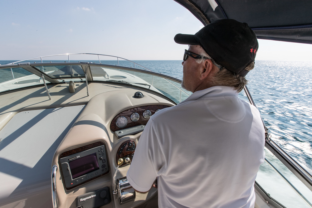
GPS (Global Positioning System) devices are extremely useful for marine navigation due to their ability to provide coordinates, time, and speed information. GPS devices can range from hand-held units to multi-function chart plotters with integrated mapping capabilities, depending on the user’s needs. They are typically powered by a 12 or 24 volt DC power supply and mounted in an accessible location on the boat.
Types of GPS Devices
- Handheld GPS – A handheld GPS unit is ideal for recreational boaters looking for a simple navigational tool. These often waterproof units typically track your current location, provide basic navigational data such as speed and direction, and may serve as an electronic compass or navigation aid for approximate navigation.
- Chart Plotters – A chart plotter uses many of the same features as a handheld unit but provides much more detailed information in a more precise way as they use maps and preloaded charts. Chart plotters can be linked up with radar systems to give warnings of upcoming storms or hazards that might be ahead along your route. With newer models featuring sophisticated mapping capabilities including AIS (Automatic Identification System), these devices become even more useful when navigating in unfamiliar waters or during night sailing.
- Marine Computers – These larger units combine chart plotting technology with powerful navigation software designed specifically for marine navigation and can include features such as route planning, weather forecasting, wind instrument integration, autopilot control systems, safety alarm monitoring and remote sailing mobile phone application data links including messaging capabilities like email or text messaging services between boats within radio range of each other’s signal strength). Multi-function color displays make them highly visible even in bright sunlight conditions making them highly desirable tools for both cruising sailors and racers alike looking for high fidelity navigational aids with superior graphical display quality over standard handheld models .
Benefits of using GPS in boating navigation
Having a GPS on board helps boat owners maximize their boating experience. There are many key benefits, including greater safety and the ability to avoid obstacles and shallow waters that can pose a hazard to the boat.
In addition, GPS allows for accurate navigation and makes it easy to keep track of your position, course and speed. GPS can also be used for tracking purposes, with some devices capable of remotely monitoring another vessel’s location or providing a comprehensive log of your own journey in case you go astray.
Finally, GPS is a great tool for chart plotting that provides an enhanced navigational experience by accurately displaying real-time landmarks, buoys and other fixed points on detailed interactive maps located on a chart plotter or a mobile app.
Maintenance and Best Practices for GPS Use in Boating
Using your GPS on the water can help keep you safe and make your ride more enjoyable. As with any navigational tool, it’s important to understand how to best maintain and use your GPS to ensure optimal results. The following tips will help you get the most out of your GPS while keeping yourself and fellow boaters safe:
-Keep all related software up-to-date; updating when new versions are available helps to ensure accuracy of the system.
-Test the GPS by navigating to familiar locations, such as ports or landmarks, before using it for serious navigation in unfamiliar waters.
-Be aware of any nonessential features that could distract from primary navigation duties and disable them if possible; despite there being no open water hazards in some areas, unexpected features like navaids or thermoclines can still appear if not disabled.
-When entering coordinates manually into a receiver (in lieu of a chart plotter) always double check that they are correct before traveling; incorrectly entered coordinates put you at risk for getting lost or worse.
-If running on an autopilot system, be sure to check and double check the navigational parameters regularly — this includes speed settings, waypoints, fuel levels and course corrections — even if these have already been entered correctly before starting a voyage.
Following these best practices will go a long way toward making sure you get the intended benefits from using your GPS. However — since boating conditions can change rapidly and without warning — it’s still important to keep a sharp lookout for any signs of impending danger should something go wrong with the device or environment around it!
Proper care and maintenance of GPS devices
GPS devices are an essential part of boat navigation and safety, and proper care and maintenance of your GPS equipment is essential to ensuring its longevity and accuracy. Before using the device, it is important to make sure the device’s batteries have been charged and that the display screen is clean and functioning properly. Additionally, it is important to regularly check for any software updates as new features may require installation or additional download time.
To keep your GPS unit in optimal condition, you should adhere to the proper cleaning techniques. It is recommended to use a microfiber cloth with water or a glass cleaner solution designed specifically for electronics when cleaning the display screen. Since many GPS devices contain waterproof coatings, you need to make sure that none of the film applied has worn off over time, as water exposure can cause damage if not adequately treated with a replacement layer of protection.
To ensure accuracy throughout extended use periods you will also want to periodically check for any internal dust buildup inside the device. This can be done by removing both batteries and accessing any vents through which dust may enter into the unit’s internal components. If needed, use compressed air available from most electronics stores in order to remove any dust from within these areas before reassembling your GPS device.
By adhering to these maintenance tips you can enjoy your boating rides with peace of mind knowing that your onboard navigation system is well taken care of!
Best practices for using GPS devices in boating
GPS (Global Positioning System) devices are invaluable tools for boaters to navigate safely on the water. GPS units measure precise location and speed through satellites, allowing boaters to determine where they are and where they should be headed. Portable GPSs offer distinct advantages over traditional maps, charts, and compasses as navigational aids since they provide accurate and up-to-date information even in remote locations. While these devices can provide a sense of security on the water, proper use of a GPS is essential to ensure safe navigation. The following sections will provide tips for the best practices when it comes to using a GPS device while boating.
1) Plan Ahead: Boaters should always have a clear plan before setting out on the water. Prepare your route at home by researching possible destinations through nautical maps or other resources. Knowing which areas to avoid due to shallow waters or heavy traffic can help prevent any potential pitfalls while also giving you insight into potential hazards you may encounter during your journey.
2) Program Waypoints: A GPS waypoint is set when a boat owner identifies any landmark or significant point along their route that can be used as reference later in their journey. Programming waypoints prior to your trip allows you to easily monitor progress towards your destination, especially if the conditions become adverse or visibility is reduced due to fog or darkness. Waypoints can also serve as markers for more technical navigation such as navigating around landmarks that aren’t clearly visible from other points of view such as islands or points of landmasses which could provide obstructions in clear sailing routes.

3) Monitor Position/Bearing/Distance: Knowing one’s exact position at all times helps prevent straying off course which may lead into rough waters that one would otherwise be unaware of if only relying on traditional navigation techniques such as nautical charts or eyeballing clearings underneath bridges etc.. If a boat owner happens to lose sight (visibility) due to intense winds/swells or foggy conditions they must remain aware of their bearing and distance travelled so they don’t drift off target or into perilous situations even if all visual cues have been lost because of low lighting or reduced visibility while underway.
4) Check Speed/Time Management: Proper time management is also an important factor when operating vessels in unfamiliar bodies of water as speed limit regulations may apply depending upon location and type of craft operating thus further helping one stay aware and safe during voyages. Paying attention and monitoring vessel speeds becomes especially important near shorelines since speeds tend worsen wakes thereby creating hazardous conditions for other vessels particularly those who are unaware of speed limits offshore. Time management by looking ahead at weather updates rather than waiting until last minute can save moments critical when less than ideal circumstances arise such as bringing back equipment before darkness falls over but still having enough daylight hours left over in order maintain adequate safety standards onboard.
Conclusion
In conclusion, GPS technology is invaluable for making sure that boats remain on course and stay safe when out on the water. GPS receivers use satellites to provide pinpoint accuracy and real-time positioning. This enables boat captains to establish a precise course, avoid potential hazards, as well as keep track of their location should they become lost or disoriented during a long sailing journey.
In addition to its primary function of vehicle navigation, modern GPS systems now also offer additional features such as route planning assistance, safety warnings, and satellite weather information. With its range of uses, the importance of GPS in ensuring boating safety cannot be overstated.
Allowing boaters to navigate safely and confidently wherever they go is one of the major benefits it offers.
FAQ’s
What is the use of GPS on boat?
GPS on a boat is used for navigation and to determine the boat’s exact location, speed, and course. It also helps with route planning and safety.
What is GPS and its role in communication and navigation?
GPS (Global Positioning System) is a satellite-based navigation system that provides location and time information. Its role in communication and navigation is to determine the user’s location and provide accurate navigation information.
How does GPS help ships and aircraft?
GPS helps ships and aircraft navigate accurately by providing real-time information on the vessel’s or aircraft’s location, speed, and direction. It helps in route planning and avoiding potential hazards.
What is GPS on a boat called?
GPS on a boat is called a marine GPS or chartplotter.
Do boats have GPS systems?
Yes, most modern boats have GPS systems installed to aid navigation.
How do boats navigate without GPS?
Boats can navigate without GPS by using traditional methods such as using charts, compasses, landmarks, and celestial navigation techniques.
What is the best boat navigation system?
The best boat navigation system depends on individual preferences and needs, but popular options include marine GPS/chartplotters, radar systems, and electronic charting systems.
What are the 4 types of navigation in ship?
The 4 types of navigation in a ship are coastal navigation, celestial navigation, electronic navigation, and piloting.
What are the three 3 main types of navigation?
The three main types of navigation are visual navigation, radio navigation, and inertial navigation.
How do you use a GPS on a ship?
To use a GPS on a ship, turn on the GPS unit, wait for it to acquire a signal, and then input the desired destination or route. The GPS will provide real-time information on the ship’s location and the direction and distance to the destination.
See Also-
- Best trucker gps 2023
- Best gps for kayak 2023
- Best gps for hunting 2023
- Best gps for geocaching 2023
- Best gps for boat 2023